The earliest origins of this family are still uncertain and subject to some hypothesis and perhaps wishful thinking. However, the first recorded presence found so far is in the area around the present-day settlement known as Banwen. They were there at the end of eighteenth century and it is thus highly likely they were indigenous; there was no reason to move there at this point, before the big in-migrations of people from all over came from the 1840s. They would have been illiterate but Welsh-speaking, and this area would resist total anglicisation longer than the more easterly valleys.
Banwen’s name maybe mutated from the original Welsh of “Panwaun” - pân a type of moorland grass and gwaun an appropriately morose and onomatopoeic description for the high, wet moorland of which Wales has so much, and which unsurprisingly also characterises this often bleak area. In the early 1800s there was little else here than a thin scattering of remote farms and smallholdings, all belonging at this time to the Miers estate, and no reason to expect anything different. Over the next one hundred years though, the area would change out of all recognition – the moorland would be mined remorselessly for iron and coal and the settlement pattern would change considerably. In the following century however, things would change again – in some senses coming full circle. Our Jones family would participate intimately in all these mutations, having been there since the start.
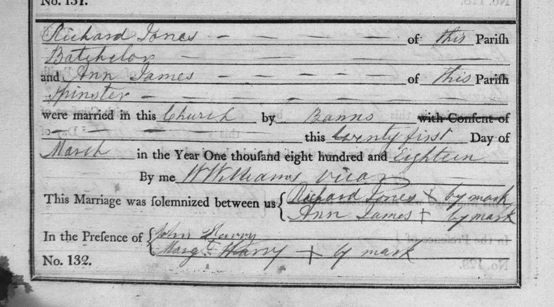
A marriage between a Richard Jones and Ann James is recorded on 21 March 1818 in the parish of Cadoxton-juxta-Neath. This parish covered a lot of ground, from Neath in the south to the Dulais Higher and Neath Higher areas about ten miles north, but the population estimated in 1801 was only about 3,500, most concentrated in the south of the parish around the town of Neath. At this time, the people in the northern reaches of the parish could probably have been counted in the scores. They very likely married in the main parish church of St Catwg but regrettably, in those days the betrothed did not have to provide any further information to the authorities, for example the details of their parents: the thrice-calling of banns and a simple declaration in the church register made the marriage official. No further civil record was kept until the introduction of compulsory civil registration in 1837. Even if non-conformist – as this couple might well have been at this stage – before 1835, all marriages had to take place in the established church.
Extract from marriage records for parish of Cadoxton-juxta-Neath, 1819
Richard and Ann were native to this area, as the record notes they are both “of this parish”, and it would be useful to tie down their pre-marital origins to a particular locality. It would be nice to confirm that one fine spring morning they emerged from somewhere on the Banwen moor to go down to St Catwg’s church to get married. A local baptismal record does exist for an Ann James, again shown at St Catwg for the 21st March 1795, father recorded as John James. A similar record for Richard Jones has not yet been found.
Tir Bach: “…there was a hamlet called Tir Bach it had a pub called the Whistle and a farm named Pantyddrainen that in the 1840's a family called Williams lived there, who then emigrated to the USA in the 1850's. One of their descendants a Mr. Kelly Williams is returning to Banwen this month.”
Email from George B Evans to author, August 2014
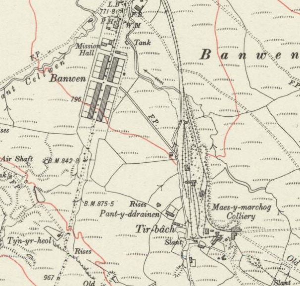
Richard and Ann Jones are seen next with five of their children on the first available (1841) census at “Tir Bach” – “small land” - which is shown on the earliest Ordnance Survey maps on the site of the old Maesmarchog Colliery at Banwen. Both gave their place of birth as the parish of Cadoxton-juxta-Neath. Tir Bach was a small hamlet around the Pantyddrainen farm. The last map reference so far found it is on the 1953 OS 1:10,000 edition: it is omitted from subsequent editions.
Map detail of the 1921 OS edition. Tir Bach is shown clearly as a settlement of some sort close to the colliery workings. The recently constructed terraces of Roman Road (from 1907) are visible, with the Pantyddrainen Hotel (P.H.) at its northern end. To mitigate, perhaps, nearby there is also a “Mission Hall”, originally a vestry for Onllwyn Independent Chapel, now demolished and presently a Kingdom Hall for Jehovah’s Witnesses. We wonder what the original Chapel folk would make of this narrow and restricted cult. Certainly no more choirs, plays or outings. The original Pantyddrainen farm is also still shown.
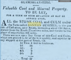
Maesmarchog – or sometimes Maes-y-marchog - and meaning the knight or horseman’s field - was the first name given to the collection of drifts in this area, slightly distant from the main Onllwyn “No. 1” colliery. Known locally later as Banwen Colliery, it was also named officially by the National Coal Board post-1947 as Onllwyn No. 3. Lewis (2003) states that the first level opened at the Maesmarchog colliery was called “Tir Bach” and so it is likely there was an original settlement of some sort here before the colliery came along. As the randomly cut drifts became consolidated into what one might term an organised colliery, the hamlet would have expanded, might have been given a name, and indeed a 1939 account mentions the “new colliery village of Tir Bach”, although “new” at this point is relative, meaning not medieval or otherwise ancient. At this time, in the early nineteenth century, mining consisted of many and various shallower and deeper drifts cut almost randomly and sometimes very speculatively into the most easily accessible out-cropping anthracite. A “colliery” in this area did not therefore consist of the neatly contained headstock and characteristic winding wheel that defined the deep mines elsewhere in south Wales. Here on the mountainside, drifts, mine workings and equipment housings sprang up randomly amongst the old cottages and smallholdings, the native small farmers and amateur miners now having to rub shoulders, willingly or not, with the new, sharp eyed prospectors and their entourages.
The people who lived on the wild Banwen moors would have been grubbing out a living for centuries, combining some subsistence arable farming, the raising of some livestock and taking greater or lesser amounts of coal according to their inclination and motivation. Now, from the beginning of the nineteenth century, they were up against something different: the interests of outside organised capital and technique in their lands and the growing realisation by the owners of these large estates that they were sitting on a fortune. With no planning law, and little foresight, development was feverish and sometimes shambolic. When the land was sold for mineral rights, the farms and settlements went with them and, depending on where drifts were cut, they might disappear into them too. Richard and Ann Jones lived in this environment and here they and their family witnessed the start of the full-scale exploitation of the Hirfynydd mountain. It was actually attacked from both sides – from Banwen to the north and Glynneath to the south. Once the drifts had run their course by the mid twentieth century, open-cast operations would scoop out the rest.
In the 1841 census enumerator’s return, the settlement of Tir Bach is listed next-but-one to Pantydrrainen Farm, now also long disappeared – but which would give its name to the future “hotel” – in Wales, like in Australia, many public houses were coyly named as such - and upon whose land it, Roman Road and the rest of Banwen village would be built. Later in 1851 and 1861, Richard and Ann Jones are recorded in exactly the same area, but now named as “Waenmarchog” – again this was a little gathering of dwellings present since at least 1841, supporting a theory of original settlement here around the small drift mines. “Waen” can mean moor, meadow or plateau and this name supports a theory that this is indeed the area at the top of the hill northwest above Maesmarchog village, part of Glynneath, just above, on the other side, the current village of Banwen. Evans (1977) states that “at one time there were 25 cottages on this estate, and the drinking water for the whole of the estate was supplied from a pump situated near the Lamb and Flag Hotel [Glynneath].” This supports the idea that the first drifts into the Hirfynydd mountain were cut from the Glynneath side and it wasn’t until about 1850 that serious inroads were made from the Banwen side.
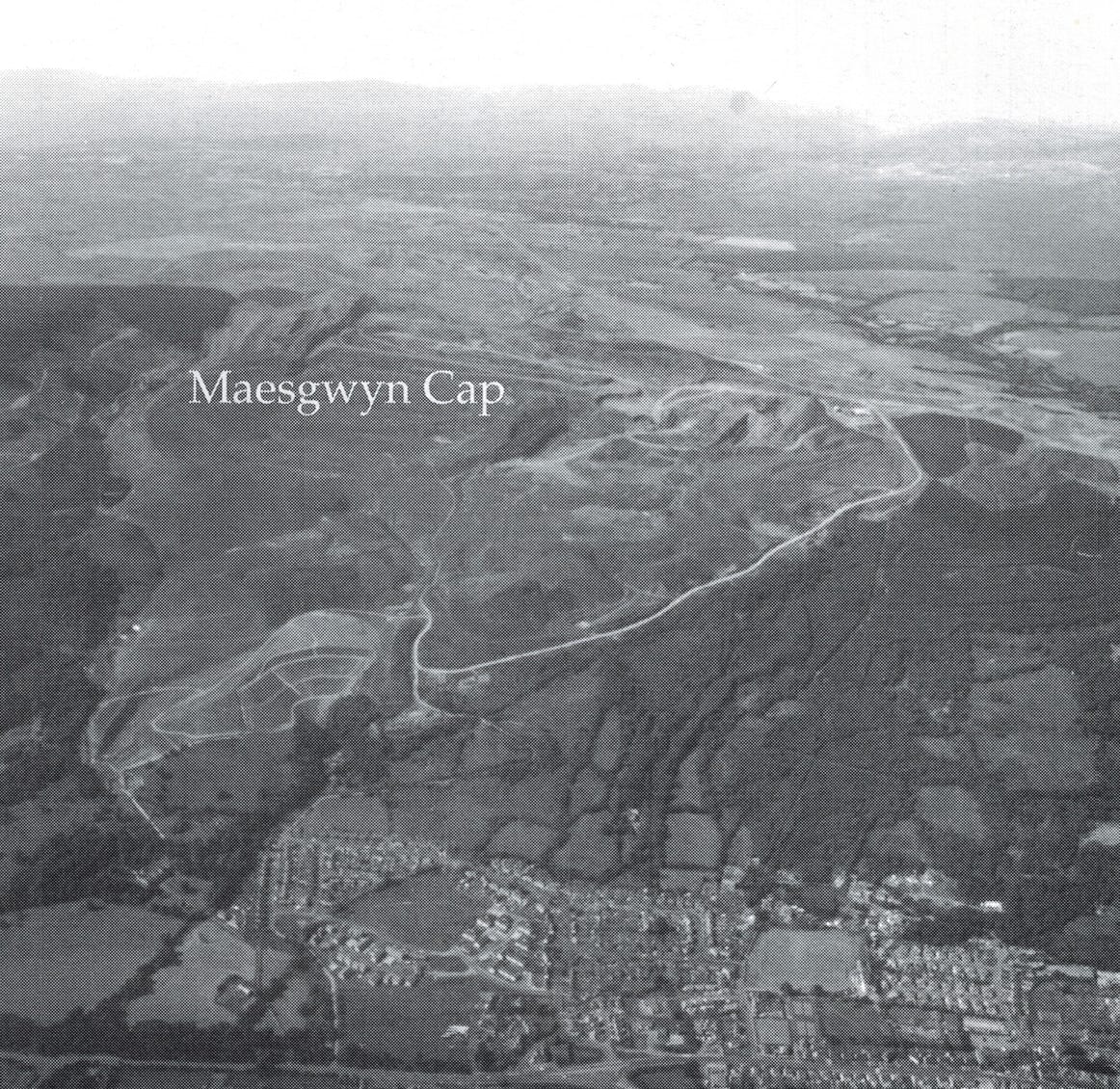
From Davies (2003): the aerial view shows Glynneath well-defined to the south, with the villages of Banwen, Dyffryn Cellwen, Onllwyn and Coelbren faintly visible over the mountain towards the north. The opencast workings and access roads are clearly visible.
We can therefore take clues from the old maps, the surrounding settlements and the paths the early census enumerators took, to originally place Richard and Ann Jones somewhere close to where today’s DOVE Workshop is today in Banwen, slightly further up the mountain to the south. Befitting its meaning, Tir Bach’s status as a settlement of any note disappeared for recognition on any future census, but what remains puzzling is its still prominent naming on the original and following OS maps. This maybe reflects its use to name not just a particular house, but a general area as well as the original coal level. It also reflects the often careless way in which census enumerators did their job: if they were local, they sometimes seemed to have assumed that everyone else would know who, what and where they were talking about; if from further afield - and especially if not Welsh-speaking - they might ignore or destroy the detail of place-names altogether.
Richard and Ann Jones’ children - six so far identified - were born into this industrial fulcrum and most of their numerous descendants would remain in the area. Development of industry and housing was – and continues to this day – to be extremely haphazard and entirely pragmatic. These are not the now carefully manicured ancient villages of England, rooted in history and growing organically over centuries. Industrial workings developed and disappeared here successively and quickly over the courses of a few decades; housing rows came and went; commercial properties waxed and waned directly according to the economic fortunes of the population. This was utility town, one of the new “raw mining townships” (Francis & Smith, 1980) and the Jones families adapted fully to its demands.
Richard Jones died sometime in the mid 1860s. By 1871, his widow Ann, aged 78, is staying with her daughter Margaret Eveleigh and her family, in Bethania Street, Glynneath and she probably died there around 1875.